Illustrative image. The City of Fort Lauderdale says work on its new neighborhood flood-sensor network began Oct. 26.
Fort Lauderdale began installing ten flood-warning sensors in its neighborhoods on Monday, Oct. 26-just as the city was recording its highest king-tide water levels since key gauges were installed. The timing is striking. The more important question is whether the new system can help the city spot changing conditions sooner and sharpen alerts where flooding is happening.
The project is called RAIN, short for Rapid Alert and Information Network. According to the City of Fort Lauderdale’s project notice, the city is partnering with Broward County to install sensors that monitor real-time weather and flood conditions. The stated goal is to improve neighborhood-level forecasting and storm alerts.
That could give local officials more information about conditions in specific areas, rather than relying only on broader forecasts. But the public notice does not say exactly how the data will be used to trigger alerts, or how much earlier residents might receive them.
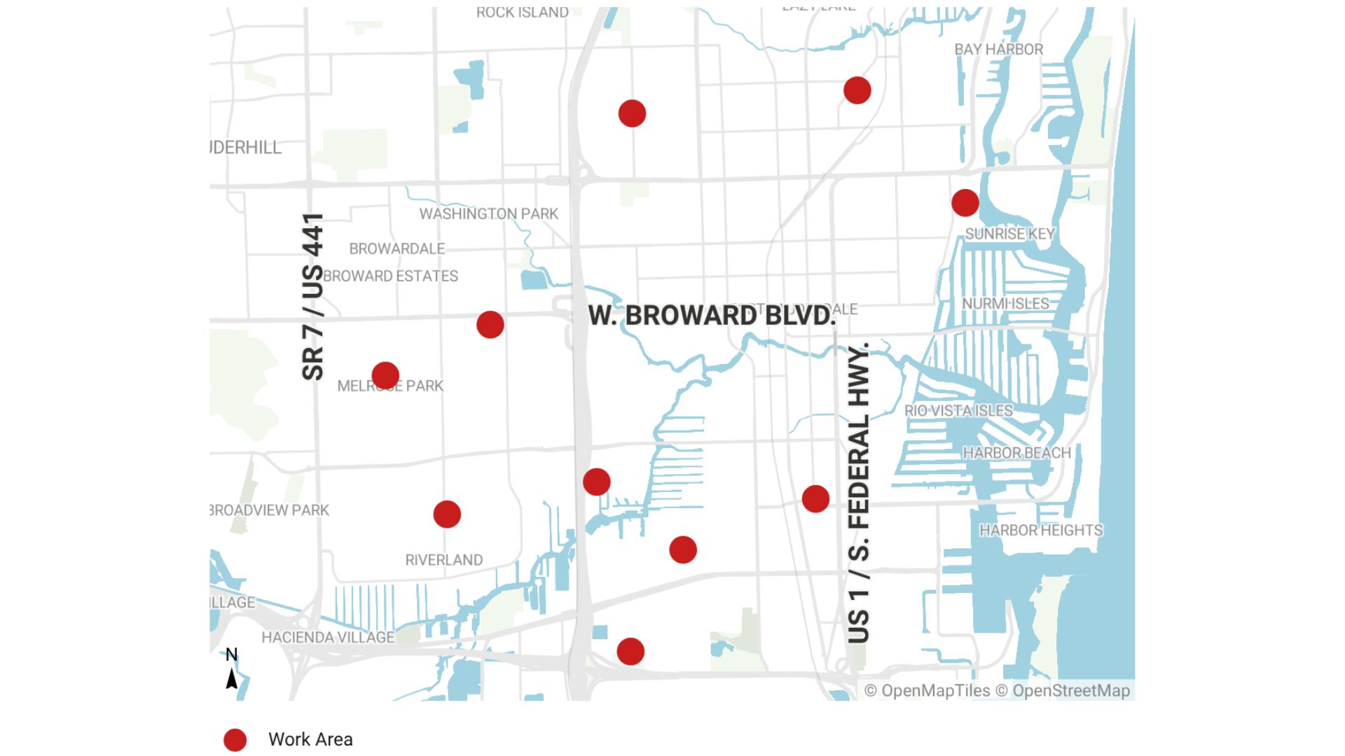
The project notice identifies ten installation locations across Fort Lauderdale. Map and project details via Pompano Beach News.
Ten neighborhoods on the installation list
The city notice names Chula Vista, Edgewood, Melrose Manors, Melrose Park, Shady Banks, Victoria Park, River Oaks, Poinciana Park, Lauderdale Manors and Middle River Terrace.
The locations include neighborhoods affected by recent or previous king-tide flooding. Middle River Terrace and Melrose Manors are near the Middle River, which crossed major flood stage Sunday at the Sunrise Boulevard gauge. Victoria Park has seen street flooding, while Shady Banks and River Oaks have flooded in previous events. Chula Vista and Edgewood sit in the southwest floodplain.
According to the city’s schedule, crews are working weekdays from 8 a.m. to 5 p.m., with about two days planned at each site. The work is expected to continue through late December, though the schedule may change because of weather or other site conditions.
Residents should expect temporary single-lane closures and brief sidewalk closures near active work areas. The city says driveway access will be maintained, with crews coordinating directly with residents if work is close to a private driveway. Pompano Beach News, summarizing the city notice, identifies FGC as the contractor.

Illustrative image, not a documented photograph of the RAIN installation or its equipment.
What the notice doesn’t tell us
There are important limits to what’s publicly confirmed. The project notice and the reporting reviewed for this article do not identify the sensor manufacturer, the cost per unit or the precise specifications of the equipment. They also do not say whether the devices measure water depth, water level using radar, or other conditions.
The notice describes the sensors’ broad purpose, monitoring real-time weather and flood conditions, but does not quantify how much they are expected to improve response times or alert accuracy. Nor does it confirm that residents will have access to a live public dashboard.
Those details matter. They will help residents understand what the devices can detect, how information will reach city responders, and what residents themselves can expect during a flood event. A NOAA radar water-level sensor shown in a stock image elsewhere should not be mistaken for Fort Lauderdale’s equipment; the city has not publicly identified its sensor model.
A timely test for a changing coastline
The installation comes after a record-setting week for local flooding. On Wednesday, Oct. 28, water ran about six inches higher than in prior king-tide events, according to Fort Lauderdale resilience officer Dr. Nancy Gassman, quoted by CBS Miami. The Port Everglades gauge also set a record since it was installed in 2018. A coastal flood advisory was in effect through 8 p.m. Thursday, Oct. 29.
Gassman warned that permanent sea-level rise could reach current king-tide levels as soon as 2040, according to NBC 6. That forecast makes better neighborhood information increasingly relevant, not just during exceptional tides, but as officials plan for future roads, buildings and infrastructure.

Illustrative image. RAIN is intended to monitor local weather and flood conditions; the city has not specified its sensor design.
The new network is a local urban-monitoring project, not an Everglades sensor system. But it reflects a wider South Florida challenge: understanding water conditions across communities, from the Everglades to the coast, as they change.
For now, the practical milestones are straightforward: installation began Oct. 26, crews are expected to work through late December, and the city notice says the schedule can shift. Residents near the listed sites can watch for temporary traffic and sidewalk closures, and should look for future city updates clarifying what the sensors measure, how alerts will work and when the network becomes operational. For ongoing local coverage, see our report on the highest king tide of the season and the rain arriving with it.